

Perimeter Plan is an AI-powered evacuation planning and traffic modeling product for pre-event planning, table-top exercises, and real-time, developing situations.
Request a DemoPERIMETER PLAN
PERIMETER PLAN
Perimeter Plan is an AI-powered evacuation planning and traffic modeling product for pre-event planning, table-top exercises, and real-time, developing situations.
Request a Demo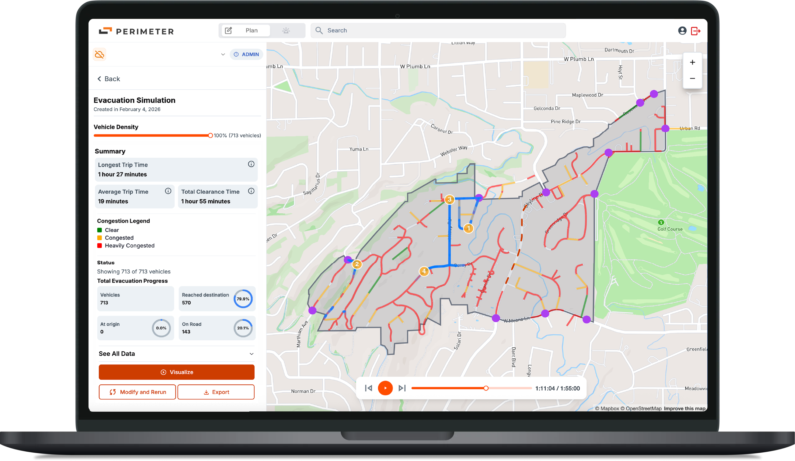


How it Works
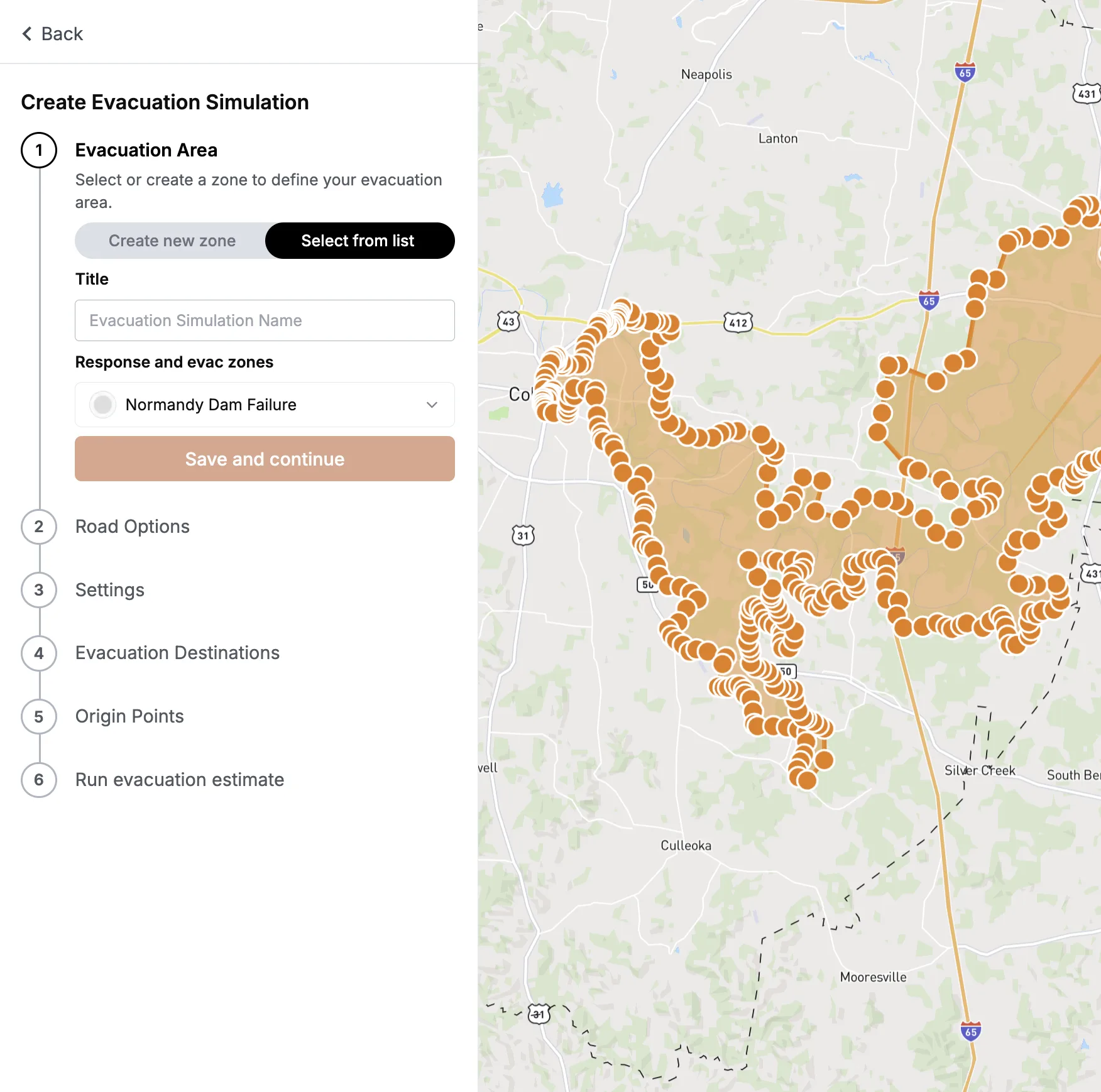
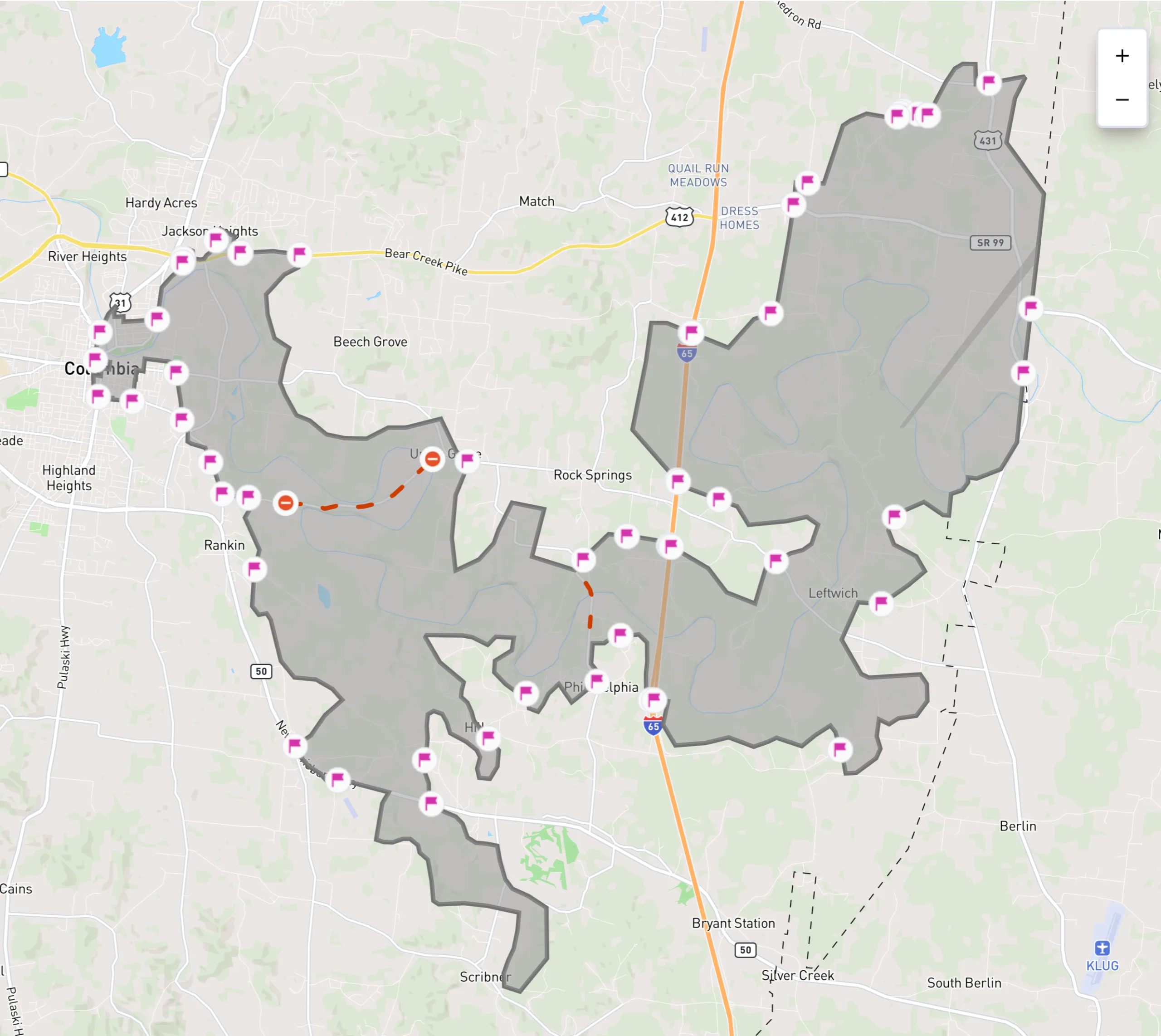
Perimeter Plan’s AI ingests millions of data points across population, geography, road networks, building infrastructure, and live traffic to simulate real-world evacuation plans and traffic models. Teams use it to verify clearance times, uncover choke points, and compare phased strategies, while designing staged departures, lane reversals, detours, and shelter-in-place boundaries by zone. You can sequence movements for neighborhoods, schools, and critical facilities before an incident. Then export scenario maps and recommended zone order into Perimeter Map. Pre-planning workflows can be activated in seconds during an incident, preserving local knowledge while speeding up decisions.

Use Cases
Agencies use Perimeter Plan to pre-plan, rehearse real-risk evacuation plans, and simulate real-time incident outcomes. Build an evacuation plan or simulate traffic in scenarios such as at-risk wildfire communities with limited exits; floods, dam breaches, and coastal surge; hazmat or refinery releases and rail derailments; hurricanes and winter storms; large venues, parades, and fairgrounds; school egress and reunification; hospital and care facility transfers; mountain and tourist corridors during holiday surges; and planned lane closures or PSPS shutoffs. Teams use it to design staged departures, lane reversals, detours, and shelter-in-place boundaries by zone, then sequence movements for neighborhoods, schools, and critical facilities before the incident.
Perimeter Plan and Perimeter Map are built to complement each other. Plan zones, sequences, clearance timelines, and route deconfliction ahead of time. During an incident, your team activates the plan, updates closures and resources, and publishes the same authoritative map to the public with a single link. From planning, response, recovery, to after-action analysis, keep everyone aligned from exercises to operations. The result is faster decisions, clearer communication, and a community that knows what to do.

Ready for Any Threat
Manage all hazards from wildfires and floods to hurricanes and active assailants. Don’t switch tools when the mission changes. Manage every incident on a single, unified platform.

Prevent Skill Fade
Don’t let the software sit gathering dust. Use Perimeter for 4th of July parades and marathons so your team is muscle-memory ready when the real disaster hits.

Zero Learning Curve
Most government software requires a PhD to operate. We don't. Your staff and volunteers will be up and running in 15 minutes. No multi-day seminars required.

Partners, Not Vendors
At Perimeter, you’re part of the family. Get 24/7/365 direct access to a US-based support team that understands the urgency of your mission, and stays with you long after the contract is signed.
"Perimeter has revolutionized our emergency communication system by providing an all-risk solution that enables efficient evacuation management, information sharing, and collaboration across different disciplines and jurisdictions."

Mary Campbell
Public Information Officer – Lodi, CA
"The Perimeter Platform was easy to learn and easy to use, and we were able to use Perimeter with our existing processes to provide immediate and up-to-date information about evacuation zones, hazardous and closed roads, and sandbag and shelter locations."

Aaron Rosenberg, Captain
Merced County Sheriff
"The problem is consistent, concise messaging. Other platforms have issues with this basic messaging feature. Perimeter offers a platform that allows the authorities to keep the messaging in real-time, with viable information, at a fraction of the cost."

Ryan Sommers, Fire Chief
North Lake Tahoe Protection District, NV
"Perimeter is a one stop shop for all the information the public needs during and emergency. You don’t have to sign up for it, it’s just a website you go to. It’s good for the community and you can do it from your phone in 60 seconds."

Troy Morton, Lieutenant OES Director
El Dorado County Sheriff’s Office, CA
Replace static PDF maps and radio chatter with a single, real-time operating picture that keeps everyone safe.
Request a Demo
