Perimeter Staff – May 15, 2024
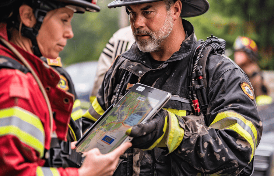
What is Emergency Preparedness Software?
Emergency preparedness software is designed to help individuals, businesses, and organizations prepare for, respond to, and recover from emergencies. These emergencies can be natural disasters such as fires, floods, or earthquakes, or human-caused events like power outages or hazardous materials spills.
There are different types of emergency preparedness software, each with its own strengths:
- Individual and family preparedness: These applications can help you create a plan, build an emergency kit, and stay informed about potential threats.
- Business continuity: This software is used by organizations to ensure critical operations can continue during an emergency.
- Large-scale emergency management: This software is used by government agencies and emergency response teams to coordinate their efforts during a crisis and may support internal collaboration and proactive communication with the community.
Top Features of Emergency Preparedness Software
There are a wide variety of emergency preparedness software available on the market. Listed below are the most essential elements to include in the evaluation of a solution.
Mass Notification Systems
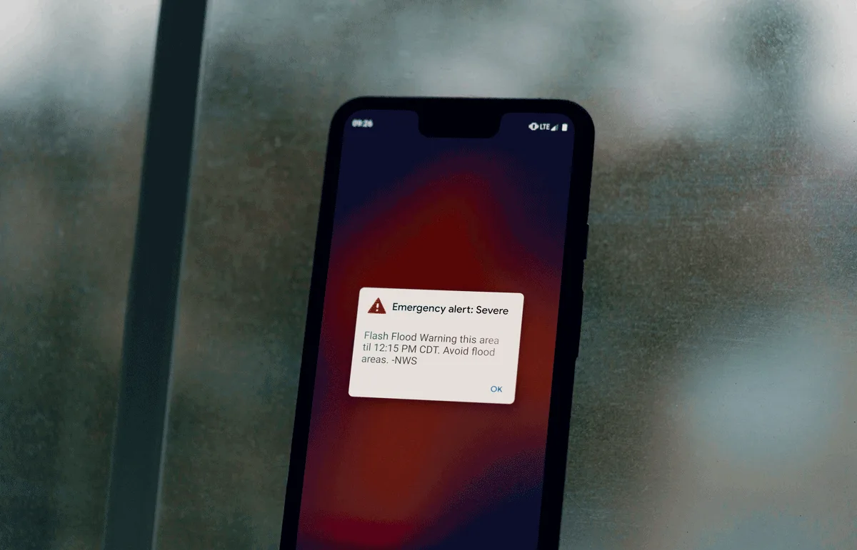
Mass notification systems are crucial for reaching a large number of people quickly during an emergency. Look for features such as ease of integration, multi-channel communication (text messages, emails, voice calls, mobile app push notifications), integration into social media channels, and the ability to target specific groups or locations.
Real-Time Collaboration Tools
Ensure teams can share information, updates, and tasks efficiently during a crisis. Features like secure chat, shared incident boards, and document sharing can streamline communication and decision-making.
Scenario Planning and Playbooks
Develop pre-defined protocols and proactive communication plans for different emergencies. This ensures everyone understands their roles and actions during a crisis, minimizing confusion and improving response times.
Resource Tracking
Keep tabs on critical resources such as personnel, equipment, and supplies during an emergency. This allows for informed deployment and allocation of resources where they’re most needed. It also supports cost recovery when the emergency has been mitigated.
Real-Time Incident Tracking
Monitor the unfolding situation with features like real-time incident data, geospatial mapping (showing location of incidents and resources), and data visualization tools. This allows for better decision-making based on the latest information.
Integration with Existing Systems
Connect your emergency preparedness software with existing tools your teams already use (dispatch software, GIS systems, crisis communication software, building management systems, etc). This avoids data silos and ensures a single source of truth during a crisis.
Incident Reporting
Capture and analyze data from emergency events. This allows for post-incident review, identification of areas for improvement, and helps refine future response strategies. This feature also supports response to public records requests.
Business Continuity Planning
Ensure your business can recover quickly after an emergency. Look for software that helps with tasks like data backup and restoration, alternate site planning, and business impact analysis.
Things to Consider When Choosing a Reliable Emergency Preparedness Software
Selecting the most suitable emergency preparedness software for your business involves a careful assessment of your needs and the software’s capabilities. Here are key factors to consider.
Identify Your Needs
- Business type and size: Consider the types of emergencies you’re most likely to face based on your industry and location.
- Target audience for notifications: Who needs to receive critical information during an emergency? Employees, customers on-site, or residents in the surrounding area?
- Existing processes and tools: How will the software integrate with your existing communication platforms, dispatch systems, or building management software?
Features and Functionality
- Communication and coordination: Does the software offer multi-channel notification, real-time collaboration tools, and scenario planning capabilities?
- Resource management and situational awareness: Can you track personnel, equipment, and supplies? Does it provide real-time incident tracking and data visualization tools?
- Reporting and recovery: Does it facilitate incident reporting and analysis for future improvement? Are there features for business continuity planning like data backup and recovery?
Additional factors
- Scalability: Will the software adapt to your organization’s growth as your needs evolve?
- Security and data privacy: What measures are in place for data risk management? How will the tool help your organization safeguard sensitive information?
- Ease of use and training: Is the platform user-friendly for administrators and responders alike? Look for available training and support resources.
9 Best Emergency Preparedness Software to Consider
Here’s a breakdown of the 9 best emergency preparedness software options for 2024.
- Perimeter
- D4H
- Konexus
- Noggin
- Vexiza
- DisasterLan
- ESRI
- Veoci
- WebEOC
1. Perimeter
Perimeter is a specialized emergency preparedness and response software designed for evacuation management during crises and collaboration during day to day operations. It prioritizes emergency communication and streamlines collaboration among emergency responders.
Key Features
- Interagency collaboration: Perimeter facilitates seamless collaboration among fire departments, law enforcement, allied agencies and emergency management agencies across jurisdictional boundaries. This streamlines operations and improves coordination during emergencies.
- Real-time public communication: The platform offers an intuitive interface specifically designed for mobile devices to facilitate real-time evacuation updates and their critical information dissemination to the public. This enables timely and transparent communication between emergency services and the community.
- Accessibility: Perimeter specifically addresses the limitations of inaccessible legacy systems. By eliminating the need for prior opt-ins or sign-ups, resolving language barriers, and providing visual guides, Perimeter ensures critical information and services are readily available to all users, regardless of their prior engagement or device preference.
- Time efficiency: Both emergency managers and the public benefit from reduced time consumption. Perimeter streamlines information sharing, potentially saving up to 12 hours compared to traditional methods employed by emergency managers and GIS technicians during disaster response. This allows for faster emergency response and timely updates for the public, ultimately minimizing the impact of disasters.
- Usability: Perimeter prioritizes a user-friendly platform optimized for mobile devices with offline capabilities. The intuitive interface and seamless navigation ensure emergency managers can efficiently utilize the system without requiring GIS technicians, saving both time and resources.
Advantages of using Perimeter
- Improved collaboration among emergency responders
- Enhanced public communication with real-time updates
- Increased accessibility of critical information for all residents
- Faster response times and improved decision-making
- User-friendly platform for efficient use by emergency operations managers
Overall, Perimeter is a well-suited software for public safety agencies looking to:
- Streamline evacuation management during emergencies
- Improve communication and collaboration among responders
- Ensure clear and timely information reaches the public during crises
2. D4H
D4H is a cloud-based emergency management software designed to empower organizations of all sizes to prepare for, respond to, and recover from emergencies. It focuses on providing a user-friendly and highly customizable platform for emergency response. It caters to a wide range of sectors including government agencies, public safety, businesses (like aviation and healthcare), and even NGOs.
Top Features
- Centralized Operations Center: Creates a virtual Emergency Operations Center (EOC) for real-time collaboration, information sharing, and situation awareness among response teams.
- Customizable workflows: D4H allows you to tailor the platform to your specific needs and emergency protocols. You can build new modules, modify forms, and adjust rules to adapt to different situations.
- Real-time features: Provides real-time incident tracking, resource allocation, and situational awareness data for informed decision-making.
- Seamless integrations: Integrates with existing communication tools and workflows to avoid disruptions and ensure a smooth transition.
- Built-in GIS mapping: Automatically populates incident maps for a clear visual picture of the situation.
- No-code customization: The interface allows for easy customization without needing programming expertise.
Advantages
- Streamlines information flow among teams and simplifies coordination during emergencies
- Real-time data and situational awareness empower informed choices
- Customizable tools and workflows help organizations plan effectively for various emergencies
- Saves time and resources by centralizing communication and automating tasks
- Adapts to the needs of organizations of all sizes
Disadvantages
- Not as mobile-friendly as other solutions
- Steep learning curve, especially with the wide range of features to navigate
Pricing
D4H offers a tiered pricing model based on the size and needs of your organization.
- D4H Personnel & Training: $1,000 – $28,000/year. Manages personnel qualifications, training, and availability
- D4H Equipment Management: $1,000 – $28,000/year. Tracks equipment inventory, maintenance, and readiness
- D4H Incident Management: $5,300 – $80,000/year. Real-time incident coordination with communication, task management, and situational awareness tools
- D4H Incident Reporting: $750 – $15,000/year. Generates reports with visualizations and data analysis for post-incident review and improvement
3. Konexus
Konexus is an emergency preparedness software designed to help organizations and government agencies communicate effectively during crises. Konexus is primarily focused on simplifying emergency notification and overall crisis management.
Top Features
- Multi-channel Mass Notification: Reach everyone you need – employees, residents, witnesses – through various channels like push notifications, text messages, emails, and voice calls. This ensures critical information reaches everyone, regardless of location or device limitations.
- Real-time Alerts and Updates: Send instant notifications with clear instructions and updates during emergencies, enabling a swift and coordinated response from your teams and the public.
- Two-way Communication: Konexus facilitates two-way communication between incident commanders and responders or the public. This allows for real-time information gathering, improving situational awareness and overall crisis management.
- Scenario Planning: Prepare for various emergencies by creating pre-defined templates and protocols for different scenarios. This streamlines communication during critical moments, ensuring everyone understands their roles and actions.
- Mobile App for Efficient Operations: Provide administrators and responders with a user-friendly mobile app for easy access to alerts, updates, critical resources, and two-way communication tools, all from a mobile device.
- Post-Crisis Reporting and Analysis: Generate reports based on sent alerts and received responses. This valuable data allows for post-crisis analysis, helping you identify areas for improvement and refine future response strategies.
Advantages
- Konexus ensures timely and clear communication with employees, the public, and other stakeholders during emergencies
- Real-time alerts and streamlined communication lead to quicker reaction times, minimizing potential damage and improving crisis outcomes
- Two-way communication and scenario planning facilitate coordinated efforts among teams, leading to more effective overall crisis management
- Real-time data from alerts and responses provides valuable insights into the unfolding situation, empowering informed decision-making
- Scenario planning allows teams to be prepared for various emergencies, minimizing confusion and ensuring a more efficient response
Disadvantages
- Konexus excels at mass notification but might lack the in-depth customization options offered by some competitors. For instance, some software allows for highly tailored emergency plans, checklists, and resource lists based on specific situations.
- While Konexus is great for communication, some software offers a wider range of emergency preparedness functionalities. This could include features like resource management tools (tracking supplies, equipment), real-time incident tracking (beyond just communication), or integrations with other tools already used by your teams (like dispatch software, GIS mapping).
Pricing
Konexus offers tiered pricing with plans designed for different needs:
- CORE: This plan is suitable for organizations needing basic emergency notification features. It includes multi-channel alerting, templates, polling, geofenced alerting, mobile app accessibility, roles & permissions, and basic reporting.
- PRO: This plan is ideal for businesses that want to add crisis management features on top of basic notifications. It includes everything in the CORE plan, plus secure mobile chat, incident management, incident guides, task lists, custom branding, and single sign-on.
- CUSTOM ENTERPRISE: This plan caters to larger organizations with specific needs. It includes everything in the PRO plan, along with critical event management, business continuity features, Archer integrations, API integrations, and in-stream translation.
While Konexus doesn’t publicly display prices, they offer a range of plans from basic notifications to full-fledged crisis management with custom options. You’ll likely need to contact Konexus for specific pricing based on your organization’s size and needs.
4. Noggin
Noggin is a critical event management software with solutions targeting all aspects of a community, including businesses as well as public safety organizations. Their Emergency Management software, Noggin Emergency, includes features to ensure situational awareness across all team members.
Top Features
- Response Plans and Checklists: Build response plans and checklists in advance to ensure your team is aligned on priorities when an incident strikes. Assign tasks to specific users, and manage roles and responsibilities from within the app.
- Mapping: Upload assets and critical infrastructure in advance of an incident using Esri ArcGIS, WMS, KML, GeoJSON, or other sources, and make updates to your ArcGIS server from within Noggin.
- Documentation and Forms: Prepare a variety of custom forms including sitreps, briefings, objectives, and incident action plans. Forms can be set up in advance, and be built to enable automatic population of fields to save time during an incident.
- Integrated Resilience Workspace: The Noggin Platform contains a wide variety of tools targeting operational and third-party risk management, operational resilience, business continuity, security operations, crisis and incident management, and emergency management. Noggin provides a centrally governed platform to consolidate disparate data.
Advantages
- Works with existing Esri products so you can take advantage of existing resources
- Highly configurable to the needs of your particular organization
- User friendly interface without requiring a technical background
- Ability to set up automation in advance to increase efficiency during disaster recovery efforts
Disadvantages
- Some features might not yet be available, as Noggin is working on building them out for future enhancements
- Public safety agencies are not target audience, which means that update timeline will not prioritize emergency management features
- High level of configuration may be needed to begin use of the platform
Pricing
Specific costs are not publicly available. However, you can contact their sales team directly for a customized quote based on your organization’s needs and deployment model.
5. Vexiza
Vexiza creates cloud-based solutions tailored to the needs of their customers. They leverage Artificial Intelligence, Big Data, and GIS technology to help public safety agencies prepare for and respond to incidents.
Top Features
- Traffic Modeling: The software is capable of processing large volumes of data to predict the effects of an incident on a community’s mobility. Can be used to manage available routes and even manage day-to-day road events.
- Forecasting and Meteorology: Track over 100 meteorological variables in real-time, including both-short term and long-term factors. Can be used to predict the effect of severe weather events on energy and utilities, emergencies, traffic, insurance, and others.
- Geographical Informational Intelligence: Capture and process geospatial data to provide improved intelligence for a wide variety of use cases, ranging from urban planning projects to infrastructure inspection.
- Real-Time Data Integration: Set up monitoring tools like live video feeds to track resources and monitor the progress of an incident once it develops, to ensure that first responders maintain situational awareness during a live scenario.
Advantages
- Specialized tool to target the needs specific to your agency
- Global focus means they support across the world
- Predictive modeling features account for changing conditions and provide unique insights
Disadvantages
- Product requires initial development time to build tool to needs of agency, so takes a while to actually use the tool
- Not built for real-time data entry, makes it difficult to communicate data outside of predefined elements to track
- Not built for all-hazards scenarios, instead focused on specific use. Focus on specific use case makes the software less flexible for changing needs case
Pricing
Contact their sales team for pricing info.
6. DisasterLan
BCG’s DisasterLAN (DLAN) is a web-based common operating picture software that incorporates task and mission tracking, resource management, and reporting features. The software helps agencies in the US and Canada prepare for, respond to, and report on emergencies.
Top Features
- Task and Mission Tracking: Assign tasks and track progress using DLAN’s Ticket Manager system. Custom automated workflows and guided data entry tools can be set up in advance to help improve efficiency during a disaster.
- Resource Management: Keep a record of staff, equipment, and critical infrastructure. DLAN can assign assets to specific requests and track the status and location of deployed assets.
- Analytics and Tracking: Generate full chronological after-action reports that can be customized based on your operational needs, to analyze results and incorporate findings into future preparedness efforts. Forms, templates, and other data collection tools can be customized as well.
- Data Visualization: Create visual situational awareness with status boards to track the status of tasks, missions, resources, etc., or view information using the software’s GIS mapping feature.
Advantages
- Custom reports and data entry tools to address your agency’s needs
- No coding knowledge required to make software customizations
- Supports data imports from a wide variety of internal and external sources for improved interoperability
- Highly responsive customer service
Disadvantages
- Steep learning curve due to wide variety of features
- The UI/UX may be unintuitive and difficult to get accustomed to
- Mapping features are limited and only available via an additional add-on
Pricing
Contact their sales team for pricing info.
7. ESRI
Esri is a GIS and mapping software that can be run on the cloud, mobile devices, or desktop. Esri’s ArcGIS products enable real-time mapping, geospatial data management, and various forms of data visualization and integrated imagery.
Top Features
- Data management and sharing: Organization data into layers across various maps and connect existing databases and live sources, such as remote sensors or video feeds. This stores related data in a common location, and provides greater context for more informed use of existing information. Data can then be easily shared with or exported for the public or other users.
- Resource management and deployment: The software allows tracking and management of emergency personnel, vehicles, and equipment. This ensures efficient resource allocation, and data can be updated live to reflect real-time needs and location data.
- Public information sharing: The solution offers tools for creating interactive maps and apps to disseminate critical information to the public during emergencies. This can include evacuation instructions, shelter locations, and safety updates.
- Damage assessment: Esri tools can be used to collect and analyze data on damage caused by the incident. This helps assess the impact and prioritize recovery efforts.
- Real-time analytics: Identify patterns and trends in larger data sets by applying spatiotemporal analytics that utilize distributed computing. This allows agencies to get more value out of the data they collect and provide improved situational awareness.
Advantages
- Improves situational awareness through real-time data visualization
- Enhances decision-making with a centralized platform for critical information
- Optimizes resource allocation and deployment during emergencies
- Facilitates seamless communication and information sharing with the public
- Offers pre-planning functionalities for better preparedness
- Integrates with existing ArcGIS Online tools for a streamlined workflow
Disadvantages
- Requires training for optimal utilization of all features
- Might have a steeper learning curve compared to simpler emergency mapping tools
- Subscription-based pricing might be a consideration for some organizations
Pricing
Specific pricing information is not publicly available and depends on the chosen plan and functionalities. Traditionally, Esri pricing has been based on a per user licensing model that can be costly as an application is scaled to accommodate additional users.
8. Veoci
Veoci functions as a virtual Emergency Operations Center (EOC) designed to empower response teams during various stages of emergency preparedness, response, and recovery.
Top Features
- Reporting and analytics: After an emergency subsides, Veoci can be used to generate reports based on the collected data. This can be valuable for post-incident analysis, helping improve future preparedness and response strategies.
- Form management: Customize IAP/ICS forms or set up public intake forms to move quickly during a live incident. Veoci includes automation features to assign tasks, workflows, and other items as soon as you launch a plan and activate.
- Resource management and tracking: Veoci allows tracking and management of emergency personnel, vehicles, and equipment. Information can be updated in real-time during an incident to ensure efficient resource allocation based on real-time needs and location data.
- Communication and collaboration: Veoci offers features for seamless communication and information sharing among responders. This includes chat functionalities, task management tools, and the ability to create event-specific online rooms for collaboration.
Advantages
- Enhances decision-making with a centralized platform for critical information
- Optimizes resource allocation and deployment during emergencies
- Facilitates seamless communication and collaboration among responders
- Integrates with various data sources for a holistic view of the situation
Disadvantages
- Can be a steep learning curve to get full value out of the tool
- Requires initial setup and customization to meet agency needs
- Limited capacity to access pre-planned maps and other resources, with greater focus on communications during and after an incident
Pricing
Contact their sales team for pricing info.
9. WebEOC
WebEOC is a web-based emergency operations center (EOC) software solution. It includes mapping capabilities with a wide variety of customization options and advanced spatial visualization features, data boards for planning and coordinating emergency management initiatives, and multi-channel communications for first responders.
Top Features
- Mapping capabilities: Users can create and annotate multiple maps to improve situational awareness during an incident or make preparedness materials more easily available. Specific mapping features include toggled map layers, external data source integrations, custom icons, live feeds to support real-time map generation, and more.
- Reporting and analytics: WebEOC offers functionalities for generating reports on various aspects of the crisis response, aiding in post-crisis reviews and future preparedness efforts.
- Real-time collaboration tools: WebEOC offers features like chat rooms, discussion boards, and task management to facilitate real-time communication and collaboration among emergency response teams. This improves collaboration before, during, and after an incident.
- Multi-agency coordination: WebEOC helps coordinate the response efforts of various agencies involved in crisis management, such as law enforcement, fire departments, emergency medical services, and public works.
- Public information sharing: The software allows controlled dissemination of public information through various channels, keeping the community informed about safety protocols and providing updates during an incident.
- Situational awareness dashboards: The platform provides centralized dashboards that display real-time information about the crisis situation, including resource allocation, weather data, and damage reports. This allows for informed decision-making throughout the response process.
- Mobile app: A mobile app keeps response teams connected and allows them to access critical information, updates, and tasks on the go.
Advantages
- WebEOC streamlines communication and collaboration among various response teams, leading to a more coordinated and efficient crisis response
- The platform provides a centralized view of the situation, enabling informed decision-making throughout the crisis
- WebEOC facilitates controlled public information sharing, promoting transparency and trust during critical situations
- The web-based solution can adapt to the needs of organizations of all sizes and can be configured to handle various crisis scenarios
Disadvantages
- While the interface is user-friendly, WebEOC offers a wide range of features, and training might be required for some users to fully utilize its functionalities
- Customization comes at an additional cost, meaning you need to pay extra to fit specific workflows or integrate the tool with existing systems
- The software may be lacking more modern export and visualization features and UI elements
Integrations may be limited and require manual reentry of some information
Pricing
Contact their sales team for pricing info.
Perimeter — Your Ideal Partner for Emergency Response Planning
While several viable options for emergency preparedness tools exist, Perimeter stands out as a simple-to-use solution that enables decision makers to curate data in advance of an incident while also making updates in real-time when an incident strikes.
Perimeter provides value beyond other preparedness solutions by fostering collaboration between agencies while also keeping the public educated and informed.
Here is why Perimeter stands out:
- Easily distribute public safety resources to your community using a simple, map-based interface to make evacuation instructions and guides easier to understand.
- Integrate with a wide variety of public safety tools to make sure all data is accessible before an incident begins.
- Support coordination with neighboring agencies by easily sharing pre-prepared resources for improved collaboration.
Contact us today to learn more about our emergency preparedness solution to learn how Perimeter can empower your community.